Year :
1989
Title :
Geography
Exam :
JAMB Exam
Paper 1 | Objectives
41 - 50 of 50 Questions
| # | Question | Ans |
|---|---|---|
| 41. |
 The largest concentration of domesticated livestock in Nigeria is found in the vegetation zone marked A. 4 B. 5 C. 6 D. 7 |
B |
| 42. |
 Mahogany, obeche , African walnut are timber trees characteristics of the vegetation zone marked A. 1 B. 2 C. 3 D. 4 |
C |
| 43. |
Kanu State is a major producer of groundnut A. Rice and kolanuts B. Millet and Sorghum C. Potatoes and Tea D. Millet and Yam |
B |
| 44. |
 The population structure depicted above is that of A. A young population B. An ageing population C. A stable population D. A declining population |
A |
| 45. |
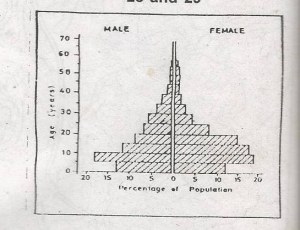 A major implication of this population structure is a A. A large productive labour force B. High dependency ratio C. Relatively low investment in social services D. High life expectancy |
B |
| 46. |
 The highest point above mean sea level in the region is just above A. 100m B. 110m C. 120m D. 130m |
A |
| 47. |
 Which of these triangulation stations is NOT visible from the edge of the quarry? A. 82 B. 94 C. 96 D. 105 |
D |
| 48. |
 The settlements in the area mapped are located mainly on the A. Flood plains B. Ridge tops C. Footslopes D. Valley floors |
C |
| 49. |
 The settlements pattern is BEST described as A. Nucleated B. Dispersed C. Linear D. Nodal |
D |
| 50. |
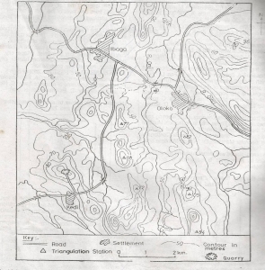 The landform between River Oni and the Kedi-Ibaga road is a A. Rolling plain B. Broken ridge C. Cuesta D. Fault-scarp |
B |
| 41. |
The largest concentration of domesticated livestock in Nigeria is found in the vegetation zone marked A. 4 B. 5 C. 6 D. 7 |
B |
| 42. |
Mahogany, obeche , African walnut are timber trees characteristics of the vegetation zone marked A. 1 B. 2 C. 3 D. 4 |
C |
| 43. |
Kanu State is a major producer of groundnut A. Rice and kolanuts B. Millet and Sorghum C. Potatoes and Tea D. Millet and Yam |
B |
| 44. |
The population structure depicted above is that of A. A young population B. An ageing population C. A stable population D. A declining population |
A |
| 45. |
A major implication of this population structure is a A. A large productive labour force B. High dependency ratio C. Relatively low investment in social services D. High life expectancy |
B |
| 46. |
The highest point above mean sea level in the region is just above A. 100m B. 110m C. 120m D. 130m |
A |
| 47. |
Which of these triangulation stations is NOT visible from the edge of the quarry? A. 82 B. 94 C. 96 D. 105 |
D |
| 48. |
The settlements in the area mapped are located mainly on the A. Flood plains B. Ridge tops C. Footslopes D. Valley floors |
C |
| 49. |
The settlements pattern is BEST described as A. Nucleated B. Dispersed C. Linear D. Nodal |
D |
| 50. |
The landform between River Oni and the Kedi-Ibaga road is a A. Rolling plain B. Broken ridge C. Cuesta D. Fault-scarp |
B |