Year :
1994
Title :
Geography
Exam :
JAMB Exam
Paper 1 | Objectives
41 - 50 of 50 Questions
| # | Question | Ans |
|---|---|---|
| 41. |
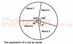 An alternative graphic method that can be used to depict the same information is the A. dot map B. proportional circle C. divided rectangle D. choropeth |
D |
| 42. |
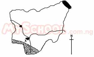 The area shaded and marked Q is well known for its A. oil palm forest B. crdue oil C. swamp rice D. ginger plantation |
A |
| 43. |
 Which important mineral is exploited at the place marked X? A. tin ore B. iron ore C. limestone D. gold |
B |
| 44. |
 What climatic type is illustrated in the graph? A. Montane B. Equatorial C. Mediterranean D. Monsoon |
D |
| 45. |
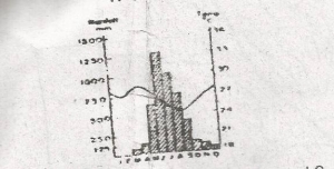 The annual range of temperature as shown in the graph is approximately A. 4oC B. 8oC C. 24oC D. 28oC |
A |
| 46. |
 The length of the main road from Robo junction to Oseb junction is approximately A. 6.5km B. 7.5km C. 8.5km D. 9.5km |
A |
| 47. |
 The relative relief of the area is slightly above A. 75m B. 105m C. 485m D. 575m |
D |
| 48. |
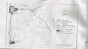 The major human activity in the area is probably A. Farming B. Fishing C. Lumbering D. Ranching |
A |
| 49. |
 The feature marked Y is best described as A. Valley B. Spur C. Gap D. Pass |
D |
| 50. |
 The roads in the area run mainly along A. Steep slopes B. Hilltops C. Gentle slopes D. Watersheds |
D |
| 41. |
An alternative graphic method that can be used to depict the same information is the A. dot map B. proportional circle C. divided rectangle D. choropeth |
D |
| 42. |
The area shaded and marked Q is well known for its A. oil palm forest B. crdue oil C. swamp rice D. ginger plantation |
A |
| 43. |
Which important mineral is exploited at the place marked X? A. tin ore B. iron ore C. limestone D. gold |
B |
| 44. |
What climatic type is illustrated in the graph? A. Montane B. Equatorial C. Mediterranean D. Monsoon |
D |
| 45. |
The annual range of temperature as shown in the graph is approximately A. 4oC B. 8oC C. 24oC D. 28oC |
A |
| 46. |
The length of the main road from Robo junction to Oseb junction is approximately A. 6.5km B. 7.5km C. 8.5km D. 9.5km |
A |
| 47. |
The relative relief of the area is slightly above A. 75m B. 105m C. 485m D. 575m |
D |
| 48. |
The major human activity in the area is probably A. Farming B. Fishing C. Lumbering D. Ranching |
A |
| 49. |
The feature marked Y is best described as A. Valley B. Spur C. Gap D. Pass |
D |
| 50. |
The roads in the area run mainly along A. Steep slopes B. Hilltops C. Gentle slopes D. Watersheds |
D |