Year :
2000
Title :
Geography
Exam :
JAMB Exam
Paper 1 | Objectives
41 - 50 of 50 Questions
| # | Question | Ans |
|---|---|---|
| 41. |
 The annual range of temperature for the town is A. 7oC B. 17oC C. 23oC D. 30oC |
A |
| 42. |
 The feature is a product of A. glacial erosion B. wind abrasion C. water erosion D. wind deposition |
B |
| 43. |
 The landform is a A. yardang B. zeugen C. mesa and butte D. rock pedestal |
D |
| 44. |
The technique that would produce the most accurate contoured map of a small area is A. Prismatic compass survey B. Land-use survey C. Plane-table survey D. Chain survey |
A |
| 45. |
In Nigeria, continentality poses the greatest hindrance to economic development in the A. Niger Delta B. Niger Benue Trough C. Cross River Basin D. Chad Basin |
D |
| 46. |
 The feature marked X is best described as a A. Pass B. Col C. Gap D. Path |
A |
| 47. |
 Tap is visible from A. Klo B. Enso C. Nino D. Ned |
B |
| 48. |
 Roads and settlements are restricted in the area because of the A. Steep hill slopes B. Mining activities C. Presence of many rivers D. Predominance of footpaths |
A |
| 49. |
 The bearing of the end of the secondary road at Ned from the road junction at Gag is approximately A. 80o B. 170o C. 260o D. 350o |
D |
| 50. |
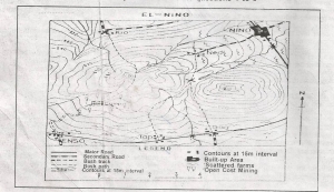 The approximate elevation of the spot height indicated on the eastern peak is A. 725km B. 715km C. 710km D. 695km |
A |
| 41. |
The annual range of temperature for the town is A. 7oC B. 17oC C. 23oC D. 30oC |
A |
| 42. |
The feature is a product of A. glacial erosion B. wind abrasion C. water erosion D. wind deposition |
B |
| 43. |
The landform is a A. yardang B. zeugen C. mesa and butte D. rock pedestal |
D |
| 44. |
The technique that would produce the most accurate contoured map of a small area is A. Prismatic compass survey B. Land-use survey C. Plane-table survey D. Chain survey |
A |
| 45. |
In Nigeria, continentality poses the greatest hindrance to economic development in the A. Niger Delta B. Niger Benue Trough C. Cross River Basin D. Chad Basin |
D |
| 46. |
The feature marked X is best described as a A. Pass B. Col C. Gap D. Path |
A |
| 47. |
Tap is visible from A. Klo B. Enso C. Nino D. Ned |
B |
| 48. |
Roads and settlements are restricted in the area because of the A. Steep hill slopes B. Mining activities C. Presence of many rivers D. Predominance of footpaths |
A |
| 49. |
The bearing of the end of the secondary road at Ned from the road junction at Gag is approximately A. 80o B. 170o C. 260o D. 350o |
D |
| 50. |
The approximate elevation of the spot height indicated on the eastern peak is A. 725km B. 715km C. 710km D. 695km |
A |