Year :
1998
Title :
Geography
Exam :
JAMB Exam
Paper 1 | Objectives
41 - 50 of 50 Questions
| # | Question | Ans |
|---|---|---|
| 41. |
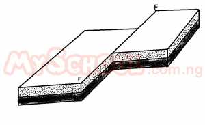 The force that is responsible for this type of process is primarily A. tensional B. compressional C. gravitational D. kinetic |
A |
|
|
||
| 42. |
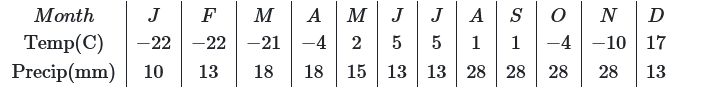
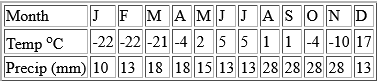
The annual range of temperature for the station is A. -27oC B. -22oC C. 17oC D. 27oC |
D |
|
|
||
| 43. |
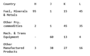
The country with a pattern of export trade similar to that depicted by J is A. Brazil B. Japan C. U.S.A D. Australia |
B |
| 44. |
With this export trade structure, the economy of H may be subject to A. fluctuation world market price for its major export B. structural adjustment programme C. huge expenditure on food import programme D. mismanagement of the export earning |
A |
| 45. |
 The climatic region represented above is A. Laurentian B. Siberian C. Arctic D. Steppe |
C |
| 46. |
 The average gradient of the road descending the spur into Bobo town is approximately A. 1:37 B. 1:42 C. 1:47 D. 1:52 |
D |
| 47. |
 The low islands and extensive sand banks indicate that the channel of River Bintu is probably A. Deep B. Eroding C. Shallow D. Navigable |
C |
| 48. |
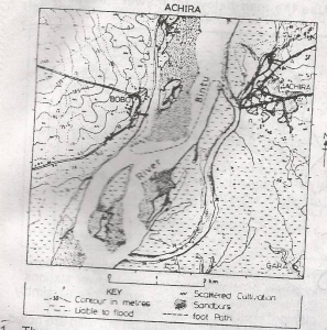 To build a road from Achira to Gara will require A. A cutting B. An embarkment C. A tunnel D. A levee |
B |
| 49. |
 Motorists will probably cross the river from Bobo to Achira by A. Drawbridge B. Ship C. Boat D. Ferry |
A |
| 50. |
 The most important factor that probably explains the distribution of cultivation on the mapped area is A. Drainage B. Settlement C. Road D. Climate |
A |
| 41. |
The force that is responsible for this type of process is primarily A. tensional B. compressional C. gravitational D. kinetic |
A |
|
|
||
| 42. |
The annual range of temperature for the station is A. -27oC B. -22oC C. 17oC D. 27oC |
D |
|
|
||
| 43. |
The country with a pattern of export trade similar to that depicted by J is A. Brazil B. Japan C. U.S.A D. Australia |
B |
| 44. |
With this export trade structure, the economy of H may be subject to A. fluctuation world market price for its major export B. structural adjustment programme C. huge expenditure on food import programme D. mismanagement of the export earning |
A |
| 45. |
The climatic region represented above is A. Laurentian B. Siberian C. Arctic D. Steppe |
C |
| 46. |
The average gradient of the road descending the spur into Bobo town is approximately A. 1:37 B. 1:42 C. 1:47 D. 1:52 |
D |
| 47. |
The low islands and extensive sand banks indicate that the channel of River Bintu is probably A. Deep B. Eroding C. Shallow D. Navigable |
C |
| 48. |
To build a road from Achira to Gara will require A. A cutting B. An embarkment C. A tunnel D. A levee |
B |
| 49. |
Motorists will probably cross the river from Bobo to Achira by A. Drawbridge B. Ship C. Boat D. Ferry |
A |
| 50. |
The most important factor that probably explains the distribution of cultivation on the mapped area is A. Drainage B. Settlement C. Road D. Climate |
A |